Choosing your first aviation headset is a big decision! It signifies that you've truly committed to this whole flight training thing. It can be a serious financial investment too, depending on the type of headset you wind up buying.
|
by guest blogger Steve Reisser of Transworld Express Our guest blogger Steve Reisser recently gave us an overview of the mind-blowing technological advances that are transforming the way pilots train, plan, and fly. In this follow-up post, he provides a few specific suggestions for getting the most out of your device and making sure it helps you improve -- not forget about! -- your situational awareness in flight. 1. AH, BUT WHICH APP? If you are an iPad user, two apps are in competition for being Number One: ForeFlight and WingX Pro. Right now ForeFlight's the winner when it comes to making the user experience seamless and intuitive and offering the best bang for your buck. WingX Pro is at least twice the expense, but it does come with synthetic vision, which can be a critical consideration if you’re dodging mountains. Garmin is trying to compete with the GDL 39 ADS-B unit, currently offered for $799 USD. It provides free weather information and ADS-B-equipped traffic updates, and can be paired with Garmin Pilot -- the company's iPad app that features the now-standard moving map, navigational charts, terrain alerts, airport diagrams, FBO information and so on.
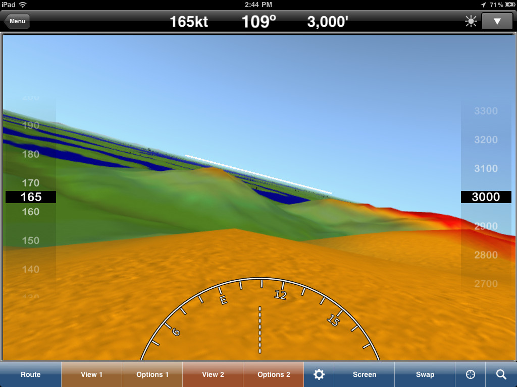
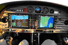 Garmin G1000 2. HMM, WHAT DOES THIS BUTTON DO, AGAIN? Know your “buttonology”! Whether you are using a panel-mounted EFIS/MFD or a handheld device, learn how to use it while on the ground and not in the air. Hook up your plane to an external power source and to practice using your shiny new toy in the hangar before ever going aloft. Just the basics of the Garmin G1000, for example, can take up four to five hours to master -- you don't want to be figuring them out while flying the plane! Make sure you understand how to program routes and manage all the displays and menus. If you’re an IFR pilot, practice multiple scenarios on the ground, including missed approach at primary, clearance changes, unplanned holdings, missed approach at the alternate, etc. Don't stop at the basics, because that's not the real world! Use this technology for scenario-based training to practice responding appropriately to whatever surprises your next flight may throw at you. 3. OOPS, WAS THAT A HOLD-SHORT LINE? Whether you are using mobile-based or panel-mounted technologies, plug in your flight plan and have your approach plates and airport information ready at a button press before your airplane moves. Pilots have made the mistake of programming while taxiing and ending up with a runway incursion incident. If it’s not set up before you move, you can lose situational awareness on the ground and in the air -- and soon you are not flying the airplane, the airplane is flying you! 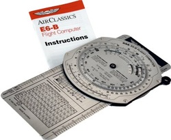 Remember me? 4. HEY, THE SCREEN JUST WENT BLANK! Always be prepared for worst-case scenarios. Mobile devices can fail, panel devices can fail, and electrical systems can fail -- so ALWAYS keep that trusty back-up of a paper map and an E6B when doing cross-country work. Few do this, but having experienced device failure on night-time cross-country flights, I know that carrying those ancient tools on board (and remembering how to use them!) can save your life! To summarize: New aviation technology is wonderful providing a huge range of tools to pilots, helping them improve their situation awareness and making the skies safer for everybody. If you're using advanced aviation technology, know it inside out before you fly, balance and manage your cockpit workload to remain visually aware of what is outside the airplane, and don't let all that technology distract you from your primary mission of flying the airplane, 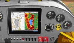 Piper iCub - an old cub learns some new tricks! Piper iCub - an old cub learns some new tricks! Aviation has been a passion for me all of my life and I have enjoyed the fruits of being a pilot for 44 years. I have also been in love with technology for most of my life, from building my own computer back when dirt was young, to keeping abreast with the latest advances in mobile devices and applications. It is exciting to see aviation being revolutionized by these new technologies. They provide ways for us pilots to develop and sharpen our skills, to plan our flights, and to keep track of our position, weather, and other traffic as we are flying. 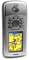 Garmin 96C Garmin 96C In the past, we were bound to a major aviation vendor such as Garmin to provide handheld technology. My first handheld GPS was a Garmin 96C. It did a great job tracking my flights, but required frequent manual downloads and uploads to the GPS to keep it current. But what a difference a few years make! The market for mobile devices has recently exploded with applications aimed at pilots. As of 9/12/2012, there were 601 aviation apps available on iTunes. There are flight-related apps for Android, BlackBerry and nearly all other mobile platforms, but it's the iPad that had the earliest development cycle of any mobile device out there. Not only are the iPad developers cranking out apps of every imaginable type, but the technology to support those apps is now filtering into our environment. Examples include integration with portable pocket-sized Attitude Heading Reference Systems (AHRSs) that can replace a whole slew of traditional aircraft instruments and navigational tools, turning your iPad into a wireless glass panel, and Automatic Dependent Surveillance-Broadcast (ADS-B), a GPS-based tracking technology capable of transmitting live weather and traffic data directly to your iPad. These technologies give us outstanding synthetic vision and enhanced situational awareness. 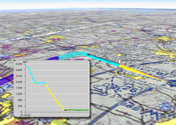 A screenshot of Cloudahoy A screenshot of Cloudahoy I am constantly amazed at the tools that are appearing. For example, if you are a student pilot or an instructor, check out the free iPad app called Cloudahoy. It will track your altitude, airspeed, and course, which is excellent for reviewing your flight lessons.
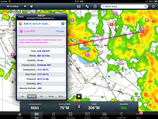
Another favourite app of mine is ForeFlight. My savings on U.S. aeronautical charts alone pay for their 75.00 USD yearly subscription fee. (At present, their Canadian navigational coverage, which will set you back an additional $150 per year, is limited to IFR charts, but plans are underway to incorporate VFR maps as Nav Canada releases them in digital format.) In my spare time I help run a charter airline -- and ForeFlight makes quoting fares a breeze! I can work out flight plans in a less than a minute, utilizing real-time weather data. I love it enroute as it tracks my aircraft giving me ETAs (in the US, we are allowed to use this as primary navigation on VFR but not IFR). I use these technologies for weather and traffic updates as well. One area where ForeFlight falls shot to its main competitor, WingX Pro, is synthetic vision. As a flatlander living and flying in Florida, I don't need the synthetic vision feature, but out west that would be almost a necessity for terrain avoidance. One caveat about having all this exciting technology at our fingertips is that we might get so overwhelmed with the extra information, we forget about the basics. Remember, that your first and foremost priority is flying the airplane. On the ground, these mobile devices and apps are invaluable for learning new equipment, studying for new certificates or ratings, pre-flight planning, etc. In the air, we must make sure that we are not so distracted by the flood of information that we lose situational awareness. Update: check out Steve's new blog post for more suggestions on how get the most out of this exciting new technology. |
 RSS Feed